Difficulty: III
Bikes:
ATB, Hybrid
The Fletcher Loop
|
Miles: 55 Difficulty: III Bikes: ATB, Hybrid |
The Fletcher Loop |
|
|
Trails Used Connecting Routes |
|
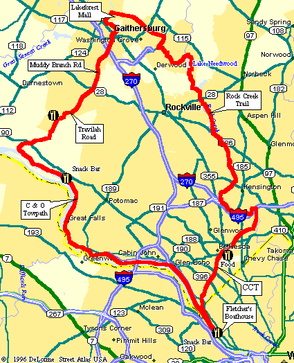
This is a great route between Gaithersburg, MD and Washington, DC. About 75% of the route uses area bike trails. These including the Rock Creek Trail, Capital Crescent Trail (with new Georgetown Branch), and the C&O Towpath. Along the way, there are some really nice points of interest, including Lake Needwood and Great Falls on the Potomac. However, some riding in traffic is required, so you need to be comfortable in these situations. The suggested starting point is right in front of the Gaithersburg Library, at the corner of Lost Knife Road and Montgomery Village Avenue. From here, the route follows the entire length of Mid-County Highway, along the nice shoulder, to Shady Grove Road. This half mile section along Shady Grove Road is the only real trouble spot and should be avoided during peak traffic hours. Thus, the best time to start this trip is early Saturday or Sunday. From here, the route mostly follows neighborhood streets to Lake Needwood.
Next, the route cuts through Lake Needwood Park to the Rock Creek Trail. This trail heads south through Rockville along the Rock Creek greenway. This trail is a bit hard to follow in some spots (see detail map of the Twinbrook area), so pay close attention to the cues. Eventually, the trail meets up with Beach Drive in South Rockville (or is it North Bethesda? <grin>). This road is a big favorite of cyclists on weekends, so you might want to use the road. If it's not too crowded, I tend to stick to the path for the first mile or two since I like to ride through the woods. Once the trail crosses Beach Drive, it's best to switch the to road. Near the Mormon Temple, the route crosses under the Beltway and follows Jones Mill Road up the hill to the Georgetown Branch Trail. The crushed limestone surface of the Georgetown Branch trail carries the route to Bethesda and the Capital Crescent Trail (CCT). The CCT is really in great shape these days, with all construction projects completed. Follow this trail for several miles to Fletcher's Boathouse, where you can grab a quick bite at the snack bar. Fletcher's is the point at which the CCT and C&O Towpath meet. If you are really gung-ho, you can continue south from here for about 3 miles to downtown D.C. Otherwise, turn around and head north on the towpath. The next 17 miles are on the C & O Canal Towpath. Between Widewater and Great Falls is a quarter mile breach in the towpath. At this point you can carry your bike, or use the optional bike detour. Take it easy going through the Great Falls area, since it is usually real crowded. Food and water are available at both Great Falls and 2 miles north at Swains Lock. The last (and hottest) leg of the route begins with a big climb out of the Potomac Valley. At the top of the hill, you pick up Travilah Road. This road has little traffic, but there is not much of a shoulder so use caution. Travilah runs into Dufief Mill Road, which then becomes Muddy Branch. An optional side path is available along Muddy Branch. Once you reach central Gaithersburg, the back streets are used to get back over to the start. If you wish to drive to the start, plenty of parking is available at Lakeforest Mall. This is easily accessible from I-270 Exit 11. After leaving the interstate, make a right at the fourth light into Lakeforest parking lot. The route begins at the following intersection. |