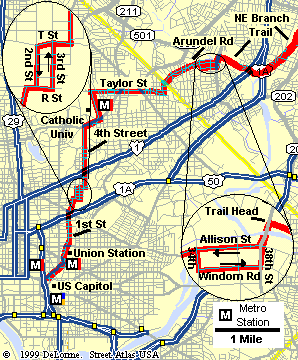
Detail of Route in DC
|
The route begins at the NW corner of the US Capitol grounds, following Louisiana Ave.
At Union Station, the route continues north along 1st and 4th Streets towards Catholic University.
This part of town is a "questionable" area of DC. Although I have not heard of cyclists
having problems, you may feel more comfortable if you ride this area in the morning hours and/or ride
with a group. Also, it would probably be prudent to avoid this area after dark.
The route then passes Catholic University along John McCormack Road and then heads east along
pleasant Taylor Street. Crossing into Maryland, the route continues along Varnum St and
Arundel Road. The route then leaves the roadway to follow the
Northeast Branch Trail up to College Park,
Maryland (trail details not shown).
There are a number of Metro Stations available
around the start. You can ride these to the start, or use them for a possible bail-out option
on the return trip. If you wish to avoid some of the rougher neighborhoods, you might opt to begin
at Catholic University. The Brookland Metro Station is easily accessable from here.
|
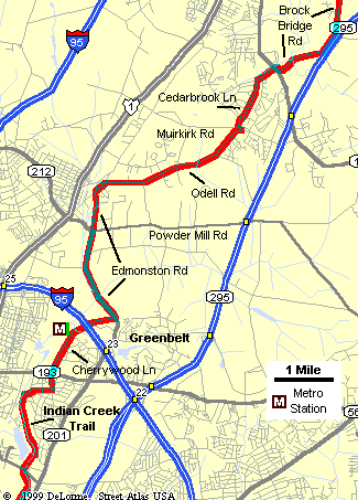
Detail of Route around Greenbelt, MD
|
This map picks up the route at the upper end of the
Northeast Branch Trail near Lake Artemesia.
The University of Maryland is located about 1 mile west of this location. Just prior to arriving
at the lake (soon after passing College Park Airport), the trail makes a couple of forks. Always
take the right fork until you see the short "hump" bridge over Indian Creek. Make a right
to cross over the bridge followed by an immediate left to continue along the east side of
the creek.
The route soon returns to the road, passing Greenbelt Metro Station along Cherrywood Lane.
(This station also provides a nice bail-out option, should you need it).
Next, the route cuts across the National Agriculture Research Center by way of Edmonston and Odell Roads.
The Ag Center provides a nice break from the previous 13 mile long urban section.
The route then passes through a small neighborhood and eventually joins Brock Bridge Road at MD 197.
I should warn you that Brock Bridge Road is a winding, two-lane road with no shoulders. On weekends
it has a reasonably low traffic volume, and thus is fairly bicycle friendly. However, I suspect this
road will not be much "fun" during weekday rush hour periods, so you may wish
to avoid this route during these periods.
|
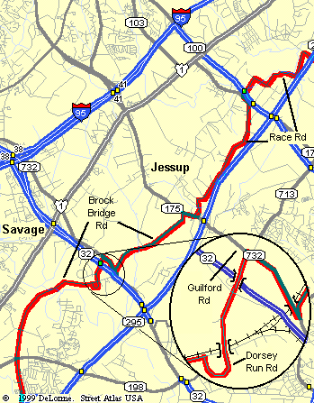
Detail of Route around Jessup, MD
|
This next section continues along Brock Bridge Road, passing just east of Laurel, MD.
Brock Bridge Road is now divided by MD 32, so you must use the short Dorsey Run detour,
as shown in the detail. On the north side of MD 32, the route begins a long climb
past two prison complexes. This section also is quite rural for the next several miles.
After crossing MD 175, the route switches to Race Road, another winding, shoulderless
road. However this road carries almost no traffic, so it is a fairly pleasant ride. Like
Brock Bridge Road, Race Road has been divided as a result of MD 100 improvements.
The Coca-Cola Drive detour is used to cross over MD 100. The ride then continues
north along Race Road until it ends at Hanover Road.
|
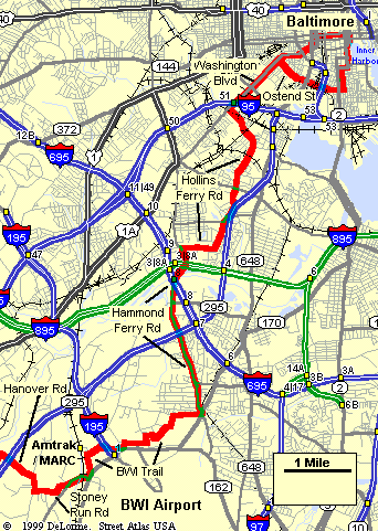
Detail of Route in Baltimore, MD
|
The route finishes it's "rural" leg using a meandering path composed of Hanover,
Ridge, and Stoney Run Roads. (There is a pretty big hill climb on Hanover). The route
then enters the Baltimore-Washingtion International Airport complex, following the
BWI Trail to the other side of the airfield. Along the way,
you will pass the Amtrak/MARC railroad station, and a few Baltimore Light Rail Stations.
The final push into downtown begins along Hammond Ferry Road. Soon after crossing under
I-895 and I-695, the route switches to Hollins Ferry Road, which requires a few up and down climbs.
You may notice that the area becomes "rougher looking" as you approach the downtown area.
Washington Blvd and Ostend Street run though a few very bleak blocks (probably not advisable at night!)
Once you pass PSInet Stadium on Ostend Street, the route turns onto Charles Street.
This is a very charming part of town with many nice pubs and shops. The route finishes at the
very popular Inner Harbor. There are many restaurant and hotel options around the Harbor area.
The return route will take you around to the other side of Camden Yards by way of Lombard Street
(lots of traffic, so use caution!) It then picks up Washington Blvd and retraces the outbound route.
|