Length:
5 Miles
Surface:
Paved
The Cross Island Trail
Kent Island
|
Length: Surface: |
The Cross Island TrailKent Island |
|
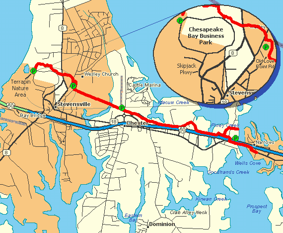
In September 2001, Queen Anne's County opened this nice little trail running across Kent Island. The Cross Island Trail starts in the Terrapin Nature Area (located directly across the bay from Sandy Point Beach) and runs all the way to Kent Narrows. This wide, paved trail offers some nice views of the Chesapeake Bay and the surrounding forests of Kent Island. The county has also constructed a couple of nice bridges along the trail which offer great views of the local waterways. Kent Island is less than an hour drive from the Capital Beltway, so this would make a nice family day trip.
If your family makes the annual "beach pilgrimage", then this trail would also provide a great
diversion to break up the long ride. In addition to bicycling, there are also over 2 miles of hiking trails
in the Terrapin Nature Area, located at the western end of the bike trail. After your ride, you can enjoy
one of the many restaurant located near the path.
Although Queen Anne County has done are really great job with this trail, there are a few issues. First, it is only 5 miles long. This makes it perfect for a family outing, but not much of a draw for more experienced riders. Also, the trail has rather large number of stop signs, some of which are questionable placed. For example, I counted at least 6 stop signs in one quarter mile section. In my opinion, many of these crossings (like the ones located in parking areas), should be directed toward cars instead of making bikes stop every few yards. Poorly placed stop signs simply encourage cyclist to disregard the law. Even more annoying are the "Biker Dismount" signs located at each crossing. Since these signs are yellow, I assume they are only a suggestion. However, I could not wonder why they did not also have signs at each crossing asking inline skaters to "Remove Skates before Crossing". Reaching the trail is quite easy:
Related Links |