C&O Canal Bicycling Guide | Print-n-go |
| Mile | Name | Info | |||||
|---|---|---|---|---|---|---|---|
| 0.0 | Mile Marker 0 (map) | Located next to the original Watergate, on the Potomac shoreline, right next to Thompson Boat Center. Accessible only from the boat center. | |||||
| 0.1 | Thompson's Boat Center (map) | 202.333.9543: Bicycle rentals (day trips only) - located about a two blocks south of the towpath trail head, right on the river shore, at the corner of Rock Creek Pkwy and Virginia Ave. | |||||
| 0.1 | Tabard Inn (map) | 202.785.1277: Located in Dupont Circle Area. 1739 N Street, NW | X | ||||
| 0.1 | Washington DC Hostel (map) | 202.737.2333: Located at 11th and K Streets, NW (near the Convention Center). | X | ||||
| 0.1 | Washington Harbour (map) | Several outdoor cafes along the waterfront. | X | ||||
| 0.3 | Start of Towpath | Just south of the Pennsylvania Ave and Rock Creek Pkwy intersection. Continue downstream via the Rock Creek Bicycle Trail. | X | ||||
| 0.5 | Georgetown Visitor Center | 202.653.5190: National Park Visitor Center. Canal boat rides available. 1057 Thomas Jefferson St, NW, Washington, DC 20007 | X | ||||
| 1.0 | Key Bridge (map) | Easy bicycle access to Rosslyn, VA, the Mount Vernon Trail, and Reagan National Airport. Many inexpensive hotels. | |||||
| 1.6 | Georgetown University (map) | Access via tunnel underneath the Canal. Near intersection of Canal and Foxhall Roads. | X | ||||
| 3.1 | Fletcher's Cove | 202.244.0461: Snack Bar. Single-speed bike and boat rentals. Nice area for a picnic. Parking available. | X | X | X | ||
| 3.6 | Capital Crescent Trail Trestle | This former railroad trestle now carries a very popular paved trail to downtown Bethesda, MD. Easier access point at mile 3.1. It is about 4 miles uphill to Bethesda. | |||||
| 4.0 | Chain Bridge (map) | Last bicycle river crossing to Virginia until Milepost 34.5 | X | ||||
| 4.7 | Maryland State Line | ||||||
| 5.0 | Lock #5 | Modern footbridge over parkway to Ridge Drive near the corner 61st Street. | X | ||||
| 5.4 | Lock #6 | Parking area along Clara Barton Parkway | X | ||||
| 5.4 | Lockhouse 6 | Stay overnight in a real lock house. Modern kitchen, bath with shower, central heat and AC. Book online. | X | ||||
| 5.8 | Little Falls Pumping Stations | ||||||
| 7.0 | Lock #7 | Parking area along Clara Barton Parkway | X | ||||
| 7.7 | Cabin John Bridge (map) | Free standing stone arch bridge, located about 0.25 mile away from river (via footbridge). Access to MaCarthur Blvd, but difficult with bicycle. | |||||
| 8.4 | Cabin John (map) | Cabin John Shopping Center (at MaCarthur and 79th St) located about 0.5 mile away from river (Deli / Store). Cross lock and follow wide path to left. Becomes paved Riverside Ave. Follow thru tunnel and continue 79th St. | X | X | |||
| 8.8 | Lock #10 | Parking area along Clara Barton Parkway | X | X | |||
| 8.8 | Lockhouse 10 (map) | Stay overnight in a real lock house. 1930s kitchen, bath with shower, central heat and AC. | X | ||||
| 9.3 | Capital Beltway (I-495) |
| Mile | Name | Info | |||||
|---|---|---|---|---|---|---|---|
| 10.8 | Carderock Recreational Area (map) | Picnic, rest rooms, water. Very easy access from I-495. | X | X | |||
| 11.5 | Marsden Tract Campground (map) | 301.299.3613: PERMIT REQUIRED - reserved for civic/scout organizations only. $20/night. Call for permit. | X | ||||
| 11.5 | Footbridge | Water on opposite side of canal. Access to MaCarthur, 0.1 mile west of Brickyard Rd. Loading only - No Parking. | X | X | |||
| 12.4 | Old Angler's Inn (map) | Popular free parking area across from Old Angler's Inn on MaCarthur Blvd. VERY Crowded. Access to optional Berma Rd route. | X | ||||
| 13.0 | Bill Goat Hiking Trail A | South Entrance: Excellent 1.7 mile hiking trail along Mather Gorge. Rejoins towpath at Milepost 13.8 Recommended if you have time, but strenuous. No Bikes. | |||||
| 13.8 | Widewater Stop Lock | This structure is used to prevent flood damage downstream. Provides access to Berma Rd, via stairs. | |||||
| 13.8 | Bill Goat Hiking Trail A | North Entrance: Excellent 1.7 mile hiking trail along Mather Gorge. Rejoins towpath at Milepost 12.8 Recommended if you have time, but strenuous. No Bikes. | |||||
| 13.9 | Mary's Wall | 75 foot wall down to river. Provides overlook to Mather Gorge. During big floods, the river rises about 10 feet over the towpath at this point! | |||||
| 14.0 | Great Falls Overlook (map) | Follow footbridges 1/4 miles out to overlook. Sorry NO BIKES allowed. Bike racks available. | |||||
| 14.3 | Great Falls Tavern Visitor Center | 301.767.3714: National Park Visitor Center. Operational Lock #20 located here. Paid parking available. 11710 MacArthur Blvd, Potomac, MD 20854 | X | X | |||
| 14.3 | Great Falls Snack Bar (map) | Hotdogs and burgers. Located in large parking area. | X | ||||
| 16.6 | Swain's Lock #21 | Five Campsites - nearby vehicle access. Newly restored lockhouse is now available for lodging with full amenities. | X | X | X | X | |
| 17.5 | Montgomery County Pumping Station | ||||||
| 19.7 | Pennyfield Lock #22 | Parking Lot - Access to River Road at Esworthy Rd | X | ||||
| 19.7 | Lockhouse 22 | Stay overnight in a real lock house. Rustic, no heat, electricity, or running water. In fact, 3 miles from nearest water source. | X | ||||
| 21.0 | Blockhouse Point cliffs | Towpath extends out into the river while passing some scenic cliffs. | |||||
| 22.1 | Violettes Lock #23 | This lock also marks the end of the watered canal basin. With a few exceptions, the canal basin is mostly abandoned upstream from this location. | X | ||||
| 22.8 | Rileys Lock #24 | Parking and access to River Road. | X | X | |||
| 22.8 | Seneca Creek Aqueduct | The first of eleven aqueducts along the towpath. The north arch was destroyed in 1973 by a thunderstorm flash flood. |
| Mile | Name | Info | |||||
|---|---|---|---|---|---|---|---|
| 26.0 | Horsepen Branch H/B | Hiker/Biker campsite. 1.2 miles from vehicle access at mile 27.2. | X | X | |||
| 27.2 | Mckee-Beshers Wildlife Area | Remote access via Sycamore Landing Rd, 0.75 miles from River Rd. Public hunting area. In July, check out the Sunflower fields during peak bloom. | X | ||||
| 30.5 | Chisel Branch H/B | Hiker/Biker campsite. 0.3 miles from vehicle access at mile 30.8 | X | X | |||
| 30.8 | Edward Ferry Boat Ramp | Access to Poolesville, MD | X | ||||
| 30.9 | Lockhouse 25 (map) | Stay overnight in a real lock house. Rustic, no heat, electricity, or running water. Nearest water is 0.3 miles downriver at campsite. | X | ||||
| 31.9 | Broad Run Trunk Aqueduct | (Ruins) | |||||
| 34.5 | Turtle Run H/B | Hiker/Biker campsite. 1.0 miles from vehicle access at mile 35.5 | X | X | |||
| 35.7 | Whites Ferry (map) | 301-349-5200: NOTE: As of Dec 28, 2020, the Ferry is CLOSED due to a legal dispute. No current access to Leesburg and no estimate if/when it may resume operation. | X | ||||
| 35.7 | White's Ferry Grill | 301.250.3077: Located right off the towpath. The grill management changed in 2019. Currently open 6 days a week - closed Mondays. Check website for latest. | X | ||||
| 38.2 | Marble Quarry H/B | Hiker/Biker Campsite. 1.4 miles from vehicle access at mile 39.6 | X | X | |||
| 39.5 | Dickerson Conservation Park (map) | Access from Martinsburg Rd. | X |
| Mile | Name | Info | |||||
|---|---|---|---|---|---|---|---|
| 41.6 | Dickerson Power Plant | US Olympic Kayak Team trains in spillway next to towpath. | |||||
| 42.1 | Monocacy Aqueduct | This impressive structure is the largest aqueduct on the towpath. Originally completed in 1833, was restored in 2005. | X | ||||
| 42.1 | Dickerson Market (map) | 301.349.5789: Food and Grocery Market located about 1.5 miles from the towpath in Dickerson. 22145 Dickerson Rd. | X | ||||
| 42.4 | Indian Flats H/B | Hiker/Biker campsite. 0.3 miles from vehicle access at mile 42.1 | X | X | |||
| 44.6 | Nolands Ferry | Boat Ramp and Picnic Area. Access from New Design Road. | X | ||||
| 47.6 | Calico Rocks H/B | Hiker/Biker campsite. 0.8 miles from vehicle access at mile 48.2. Located near a busy railroad line, so earplugs are suggested. | X | X | |||
| 48.2 | Point of Rocks, MD | This town marks the location where the Potomac river cuts through the Catoctin Mountain ridge. The Route 15 Bridge provides alternate bike access to Virginia (when Whites Ferry is closed). Note that Route 15 is very hazardous and NOT recommended for bicycle access to Leesburg. Use state route 665 instead. | X | ||||
| 48.2 | One Stop Deli and Grocery (map) | 301.874.2691: Small Deli located in Exxon, about 0.7 miles from Towpath (just past the train station). | X | ||||
| 48.2 | Aroma House (map) | 301.874-8100: Pizza and Gyros, located 0.7 miles from the towpath (just past the train station). 1595 Bowis Dr | X | ||||
| 48.2 | Roadhouse Jerk (map) | 301.810.5782: Jamaican cuisine just off the towpath in Point-of-Rock, MD. Lunch, and dinner. 3710 Clay St. | X | ||||
| 49.0 | Lockhouse 28 | Stay in a real lock house. Rustic, no heat, electricity, or running water. Nearest water is 1.4 miles upstream. Close proximity to active railroad, so earplugs are a must for sleeping. | X |
| Mile | Name | Info | |||||
|---|---|---|---|---|---|---|---|
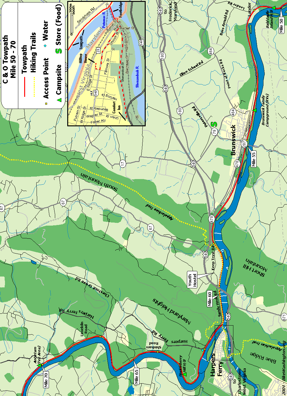
| 50.3 | Bald Eagle Island H/B | Hiker/Biker campsite. 0.5 miles from vehicle access at mile 50.8. Located near a busy railroad line, so earplugs are suggested. | X | X | |||
| 50.9 | Lock 29 | Access from Lander Road | X | ||||
| 51.5 | Catoctin Creek Aqueduct | The number 3 aqueduct is noted for the unusual center arch. It completely collapsed in October 1973. The beautifully restored aqueduct was completed in 2011. | |||||
| 52.5 | Culvert 82 Washout (map) | In May 2018, this culvert was destroyed by flooding. The towpath was impassible at this point until summer 2019 when the park service installed a temporary low-water crossing. | |||||
| 54.0 | Brunswick Family Campground (map) | 301.834.9950: Private Campground - Showers. Located between towpath and river. Appears to be VERY popular with RVs, but expect railroad noise. Cabin and Bicycle Rentals also available. | X | ||||
| 55.0 | Brunswick, MD | Ample parking. A couple of restaurants, but no easily accessible convenience stores. Access to Virginia via route 17/287 | X | ||||
| 55.0 | Brunswick Heritage Museum (map) | 301.834.7100: 1/4 mile from canal in downtown Brunswick (about 1 block past the railroad station). Includes 1700 square foot HO Scale model railroad. Also houses the Brunswick C&O Visitor Center. Open Fri, Sat, and Sun only | |||||
| 55.0 | Georges Mill Farm B&B (map) | 540.822.5224: Lovettsville, VA - about 5 miles south along Route 287. | X | ||||
| 55.0 | Beans in the Belfry (map) | 301.834.7178: Popular internet cafe located 0.3 miles from towpath in old church. Offering coffee, sandwiches, soups, salads, and WiFi. Go past the railroad station and turn left at the light. Just past the top of the hill near the bridge. 122 West Potomac St. | X | ||||
| 55.0 | Brunswick Visitor Center (map) | 301.834.7100: 40 West Potomac Street, with railroad Museum | |||||
| 55.0 | Potomac Street Grill (map) | 301.969.0548: American, Tex-Mex, and Middle Eastern food. 31 E Potomac St. | X | ||||
| 55.0 | King's Pizza (map) | 301.834.9999: Go past the railroad station and turn left at the light. Just past the top of the hill one the other side of the bridge. 215 West Potomac St. | X | ||||
| 55.0 | Three Points Cycle (map) | 301.834.7199: Full Service bicycle shop. Located just 150 yards from the towpath. 5 West Potomac St, Brunswick, MD 21716 | |||||
| 55.0 | Smoketown Brewing Station (map) | 301.834.4828: Enjoy a brew at the town's former former fire station. Feel free to bring your own food or visit any of our town's great restaurants (King's Pizza is right around the corner). 223 Potomac Street. | X | ||||
| 58.0 | River & Trail Outfitters (map) | 888.446.7529 : Bike Rentals and other recreation services | |||||
| 58.0 | Appalachian Trail | The famous 2,181 mile long hiking trail that runs from Maine to Georgia. The trail comes down off South Mountain, and follows the towpath upstream for about 3 miles, leaving at Harpers Ferry. | X | ||||
| 60.2 | Sandy Hook, MD (map) | ||||||
| 60.7 | Harpers Ferry, WV (map) | National Historic Park. Railroad Station, serving Amtrak and MARC (No bicycles on MARC). IMPORTANT: The footbridge to Harpers Ferry was destroyed by a train derailment in Dec 2019. It is closed until further notice. | X | ||||
| 60.7 | Quality Inn (map) | 304.535.6391: 25 Union Street, Harpers Ferry, WV - about 1.5 miles from towpath. From the historic area, follow Shenandoah St to Rt 340, then go right on the wide shoulder for about 100 yards. Hotel will be on the right. This avoids the hill on Washington St. | X | ||||
| 60.7 | River Riders | 800.326.7238: Harpers Ferry, WV - half day bike rentals for $25. Also offers multiday tour packages | |||||
| 60.7 | Harpers Ferry Dining (map) | Numerous restaurant options on the block across from the railroad station. Coffee, delis, pubs, self serve, ice cream. Mostly lunch and dinner options. Online ratings favor Cannonball Deli and Private Quinn's Pub. | X | X | |||
| 60.7 | The Town's Inn (map) | 877.489.2447: This recently renovated inn is the only lodging in Lower Town Harpers Ferry, and closest option to the Towpath. 21 beds in 7 rooms. 179 High Street, Harper's Ferry, WV | X | ||||
| 60.7 | Harpers Ferry Outfitters (map) | 304.535.2087: General Store location (near railroad station) offers bicycle rentals and basic bike parts (such as tubes). Full service hiking equipment on block up the hill. | |||||
| 61.2 | Maryland Heights Hiking Trail (map) | Use footbridge over canal - Hiking trail to top of cliffs overlooking Harpers Ferry | X | ||||
| 61.5 | Harpers Ferry Road Access | Very small parking lot. No parking on weekends (raft access only) | X | X | |||
| 62.9 | Huckleberry Hill H/B | Hiker/Biker campsite. Remote - No nearby vehicle access. | X | X | |||
| 64.9 | Dargan Bend Recreation Area | Large Parking Area (40-50 vehicles) - Access from Back Rd | X | ||||
| 67.4 | Mountain Lock Recreation Area | Parking Area (10-15 vehicles) - Access from Limekiln Rd, just down hill from Harpers Ferry Rd | X | ||||
| 69.3 | Antietam Aqueduct | The forth of 11 stone aqueducts constructed. Crosses Antietam Creek, which flows through the famous battlefield. | |||||
| 69.8 | Antietam Creek Recreation Area | Easy vehicle access - 20 Campsites - Fee Area: $10/Night | X | X | X |
| Mile | Name | Info | |||||
|---|---|---|---|---|---|---|---|
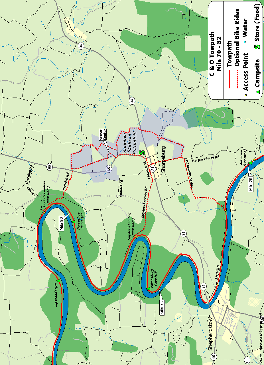
| 71.5 | Pack Horse Ford | Conferderate Army crossed here after the Battle of Antietam | |||||
| 72.8 | Route 34 Bridge | Large Parking Area, about 0.1 mile downriver from bridge. Restaurants located across river in Shepherstown, about 3/4 mile. | X | X | |||
| 72.8 | Bavarian Inn (map) | 304.876.2551: Directly across river via Route 34 Bridge. Probably one of the nicest places to stay along the towpath. | X | ||||
| 72.8 | Thomas Shepherd Inn (map) | 888.889.8952: Cross Route 34 Bridge. About 1/2 Mile past Bavarian Inn | X | ||||
| 72.8 | Clarion Hotel (map) | 304.876.7000: On the far side of town, past the Thomas Shepherd Inn. | X | ||||
| 72.8 | Comfort Inn (map) | 304.876.3160: Cross Route 34 Bridge. Right onto Route 45. Located on right at 2001 Maddex Square Drive. | X | ||||
| 72.8 | Shepherdstown Dining (map) | Numerous dining options in this university town, including pizza, Chinese, and Thai. Cross bridge and ride up the hill. Left at 4-Way stop onto W German Street. | X | ||||
| 72.8 | Blue Moon Cafe (map) | 304.876.1920: Popular pub just one block off the beaten path. Corner of Princess & High Streets. | X | ||||
| 72.8 | Shepherdstown Pedal and Paddle (map) | 304.876.3000: Full service bicycle repair shop, including bicycle parts and rentals. Open most days by noon. 115 W. German Street | |||||
| 75.3 | Killiansburg Cave H/B | Hiker/Biker campsite. 1.3 miles from vehicle access at mile 76.6 | X | X | |||
| 75.7 | Killiansburg Cave | Large Cave about 20 above path in cliffs. (Hard to see through summer foliage) | |||||
| 76.8 | Snyders Landing Boat Ramp | Easiest access to Sharpsburg and Antietam Battlefield | X | ||||
| 76.8 | Jacob Rohrbach Inn (map) | 301.432.5079: A Bed and Breakfast in Sharpsburg, MD - About 1 mile from trail, near Antietam Battlefield. 138 W. Main St. | X | ||||
| 76.8 | Barron's Canal Museum (map) | A long time fixture on the canal, now owned by the Tyler Family. Open on weekends only. | |||||
| 76.8 | Antietam Guest House (map) | 301.992.9767: Quiet location in Sharpsburg, just one block off Main Street. Locked bike store. Great food nearby | X | ||||
| 76.8 | Battleview Market (map) | 301.432.2676: A bit off the trail, but the deli here is a great food option when visiting the Antietam Battlefield. 5331 Sharpsburg Pike. | X | ||||
| 76.8 | Captain Benders Travern (map) | 301.432.5813: Great food, micro-brew beers, wine and mixed drinks. Easy trek from Snyder's Landing into town. Not far from Antietam Battlefield. 113 East Main Street | X | ||||
| 76.8 | Antietam National Battlefield (map) | 301.432.5124: Location of the bloodiest one-day battle in US history. On Sept 17, 1862, nearly 23,000 solders were killed at this location. The auto tour route also makes a nice bicycle tour. | |||||
| 79.9 | Horseshoe Bend H/B | Hiker/Biker campsite. 1.1 miles from vehicle access at mile 81.0 | X | X | |||
| 80.9 | Taylors Landing Boat Ramp | Access to Antietam Battlefield | X |
| Mile | Name | Info | |||||
|---|---|---|---|---|---|---|---|
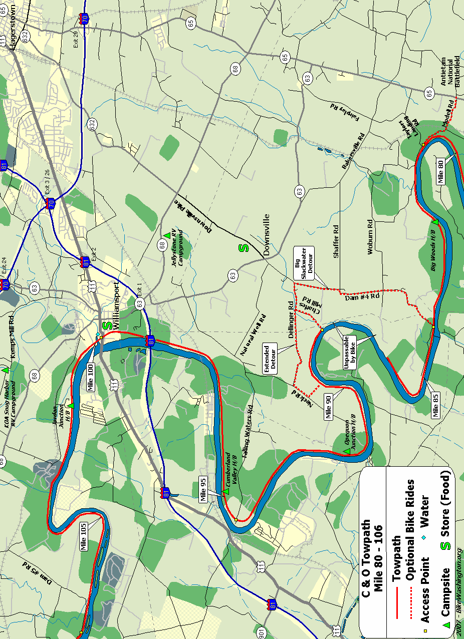
| 82.5 | Big Woods H/B | Hiker/Biker campsite. 1.5 miles from vehicle access at mile 81.0 | X | X | |||
| 84.2 | Dam #4 | X | |||||
| 84.2 | Downsville General Store (map) | 301.223.6401: Small Deli located in Downsville, MD. About 1 mile off the detour via Dam Number 4 road | X | X | |||
| 90.9 | Opequon Junction H/B (map) | Hiker/Biker campsite. Remote - No nearby vehicle access. | X | X | |||
| 93.8 | Potomac Fish and Game Club | 301-223-9871: Private club. Public access may be restricted. | X | ||||
| 94.3 | Falling Waters | Confederate Army crossed here after the Battle of Gettysburg. | |||||
| 95.2 | Cumberland Valley H/B (map) | Hiker/Biker campsite. Remote - No nearby vehicle access. | X | X | |||
| 98.6 | I-81 Overpass | ||||||
| 99.1 | Lock 44 (map) | Functional lock on the edge of town. Alternative access point into downtown Williamsport for loaded bicycles. | |||||
| 99.4 | Williamsport Visitor Center | 301.582.0813: National Park Service Visitor Center. Great displays inside the Cushwa building. A Bike Repair Station is also available at this location. | X | ||||
| 99.4 | Red Roof Inn (map) | 301.582.3500: Williamsport, MD - Located about 1 Mile from the towpath, along Potomac Street (Route 11) | X | ||||
| 99.4 | Jellystone Park (map) | 301.223.7117: Private Campground - Full Service RV and Cabins. Located 2 Miles south of Williamsport along Route 68. Showers, pool, camp store. | X | ||||
| 99.4 | Hagerstown KOA (map) | 301.223.7571 : Private Campground - Full Service RV and Cabins. Located 3 Miles north of Williamsport along Kemp Mill Rd. Showers, pool, camp store. | X | ||||
| 99.4 | Tony's New York Pizza (map) | 301.223.6266: Great place to load up on carbs. Corner of Salisbury and Conococheague Streets | X | ||||
| 99.4 | Desert Rose Cafe (map) | 301.223.6400: Swing by for a cup of soup, a healthy sandwich or salad and perhaps an espresso or smoothy. Recently relocated to a larger space at 42 N Conococheague Street | X | ||||
| 99.4 | Third Base Tavern (map) | 301.223.8274: Great place to cool off with a beer. 35 N. Conocheague St | X | ||||
| 99.4 | Bay Farms Bed and Breakfast (map) | 301-875-5032: Located in downtown Williamsport, just two blocks from the towpath. 14 N Conococheague St. | X | ||||
| 99.4 | Elmwood Farm Bed & Breakfast (map) | 240.707.0772: A relaxed and comfy farm stay experience, located 2.5 miles outside of Williamsport, MD. Shuttle service available. 16311 Kendle Road. | X | ||||
| 99.5 | Conococheague Aqueduct | Pronounced KAH-no-KAH-cheek, the number five aqueduct was completed in 1835. Notable for the wooden upstream wall, which collapsed on three different occasions, most recently in 1920. The aqueduct was completely restored in Aug 2019, and is currently the only watered aqueduct along the towpath. | |||||
| 101.2 | Jordan Junction H/B (map) | Hiker/Biker campsite. 1.9 miles from vehicle access at mile 99.3 | X | X |
| Mile | Name | Info | |||||
|---|---|---|---|---|---|---|---|
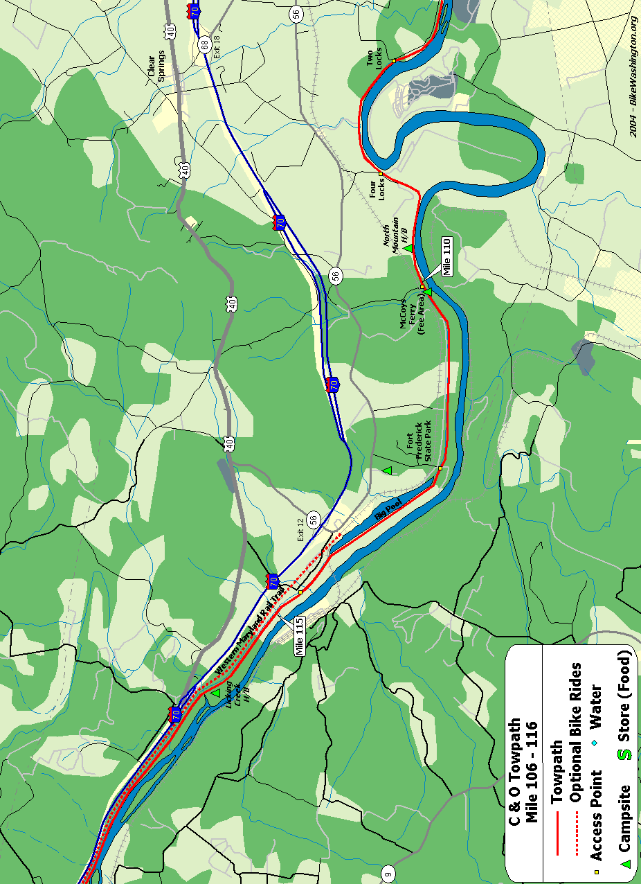
| 106.6 | Feeder Dam #5 | Access via Dam #5 Road - Parking Area. | X | ||||
| 108.1 | Charles Mill | Ruins located on berm side of canal. | |||||
| 108.6 | Four Locks | Large parking area, boat ramp. | X | ||||
| 108.7 | Lockhouse 49 | Stay overnight in a real lock house. Electricity with baseboard heating and stove, but no running water. Water pump nearby. | X | ||||
| 109.6 | North Mountain H/B (map) | Hiker/Biker campsite. 0.4 miles from vehicle access at mile 110.0 | X | X | |||
| 110.0 | McCoys Ferry Recreation Area (map) | Primitive RV and Tent Camping - Fee Area $10/night | X | X | |||
| 112.1 | Fort Frederick State Park (map) | ?301.842.2155: Massive pre-revolutionary fort. Easy access from towpath. Water is available from hydrant, just 20 feet past the railroad crossing on the left. | X | X | X | ||
| 112.5 | Big Pool | East End | |||||
| 114.0 | Big Pool | West End | |||||
| 114.5 | Western Maryland Rail Trail (map) | Eastern Access Point. Trailhead located 0.7 miles downstream of this point at Route 56 | X | ||||
| 116.0 | Licking Creek H/B | Hiker/Biker campsite. 1.5 miles from vehicle access at mile 114.5. Located Near I-70 - Subject to traffic noise. Earplugs suggested for camping. | X | X | |||
| 116.0 | Licking Creek Aqueduct |
| Mile | Name | Info | |||||
|---|---|---|---|---|---|---|---|
| 116.0 | Licking Creek H/B | Hiker/Biker campsite. 1.5 miles from vehicle access at mile 114.5. Located Near I-70 - Subject to traffic noise. Earplugs suggested for camping. | X | X | |||
| 116.0 | Licking Creek Aqueduct | ||||||
| 120.4 | Little Pool H/B (map) | Remote Hiker/Biker campsite - No vehicle access. Located Near I-70 - Subject to traffic noise. Earplugs suggested for camping. | X | X | |||
| 123.0 | Tonoloway Creek Aqueduct | ||||||
| 124.1 | Hancock, MD | Several Stores and Restaurants. Very easy access from towpath | X | ||||
| 124.1 | Park-N-Dine Restaurant (map) | 301.678.5242: 189 E Main St | X | ||||
| 124.1 | 1828 Trail Inn (map) | 301.678.7227: Hancock, MD - Bed and Breakfast located just one block from the trail. 10 West Main Street. | X | ||||
| 124.1 | Riverrun B&B (map) | 301.678.6150: Probably one of the closest accommodations to the towpath, and several recommendations from 2010 travelers. 7 South Taney Street. | X | ||||
| 124.4 | Super 8 Motel (map) | 301.678.6101: Hancock, MD - Travel one block away from river and turn left on Main Street. Hotel is located on far side of overpass. | X | ||||
| 124.4 | Triangle Tavern (map) | 301.678.6175: Excellent food, well stocked bar. Owner and staff very friendly to the hiker/biker community. 200 E Main Street, Hancock, MD | X | ||||
| 124.4 | C&O Bicycle (map) | 301.678.6665: Hancock, MD - Full Service Bike Shop, right next to the towpath on Penn Ave. Also offers overnight bunk house and snacks. Open 8am to 6pm daily. | X | X | |||
| 124.4 | Weaver's Restaurant (map) | 301.678.6346: A towpath favorite. Great deserts! 77 W Main St | X | ||||
| 124.4 | Buddy Lou's (map) | 301.678.6460: Light menu, mainly sandwiches and finger food, micro-brew beers, wine and mixed drinks. Nice deck overlooking the rail-trail. 11 E Main Street | X | ||||
| 126.4 | White Rock H/B (map) | Hiker/Biker campsite. 1.2 miles from vehicle access at mile 125.2 | X | X | |||
| 127.4 | Round Top Cement Mill | ||||||
| 129.8 | Leopards Mill H/B (map) | Hiker/Biker campsite. 0.9 miles from vehicle access at mile 130.7 | X | X | |||
| 130.0 | Happy Hills Campground (map) | 301.678.7760: Private Campground - Full Service RV and Tent Camping (200 Sites). Cabins and Horse Stables available. 12617 Seavolt Rd | X |
| Mile | Name | Info | |||||
|---|---|---|---|---|---|---|---|
| 130.0 | Happy Hills Campground (map) | 301.678.7760: Private Campground - Full Service RV and Tent Camping (200 Sites). Cabins and Horse Stables available. 12617 Seavolt Rd | X | ||||
| 130.7 | Cohill, MD | Access from Route 144 via Willow Road | X | ||||
| 133.6 | Cacapon Junction H/B (map) | Remote Hiker/Biker campsite - No vehicle access. | X | X | |||
| 136.3 | Western Maryland Rail Trail (map) | Western trailhead at Lock 56 in Pearre, MD. This paved trail runs parallel to towpath for next 21 miles | |||||
| 136.6 | Sideling Hill Creek Aqueduct | ||||||
| 139.2 | Indigo Neck H/B (map) | Hiker/Biker campsite. 1.6 miles from vehicle access at mile 140.8 | X | X | |||
| 140.8 | Town Hill Hotel B&B (map) | 877.696.2794: Located on top of Town Hill Mt providing beautiful vistas. About 8 miles from Little Orleans. A shuttle service is available, with multiple pickup points. But for extra credit, bike the 1,300 foot climb yourself! | X | ||||
| 140.8 | Bill's Place (map) | 301.478.2701: This bar is a longtime favorite stop along the towpath. Closed Tuesday and Wednesday | X | ||||
| 140.8 | Fifteen Mile Creek Recreation Area (map) | Fee Area: $10 to $20. A Drive-in site with RV and tent sites (Primitive Facilities - No RV Hookups). Free parking available alongside railroad embankment. | X | X | X | ||
| 140.8 | Little Orleans Campground (map) | 301.478-2325: Private Campground - RV and tent sites 1/4 mile from the towpath. Showers, pool, camp store. | X | X | |||
| 140.9 | Fifteen Mile Creek Aqueduct | ||||||
| 144.0 | Long Pond Trail | 7 mile hiking trail to Green Ridge State Forest Visitor Center | |||||
| 144.5 | Devil's Alley H/B (map) | Remote Hiker/Biker campsite. No vehicle access. | X | X | |||
| 149.4 | Stickpile Hill H/B (map) | Remote Hiker/Biker campsite. Rough access point 0.6 miles away at Mile 150 | X | X | |||
| 150.0 | Bonds Landing | Rustic access point from Kasecamp Road. Four wheel drive may be required. | X |
| Mile | Name | Info | |||||
|---|---|---|---|---|---|---|---|
| 150.0 | Bonds Landing | Rustic access point from Kasecamp Road. Four wheel drive may be required. | X | ||||
| 151.1 | Three Otters Eco Retreat (map) | 304.947-5446: Some really unique lodging options are available, just across the river from the towpath. They also offer convenient canoe ferry service. | X | X | |||
| 153.4 | Gross Hollow | Very rustic access point from Sportsman Club Rd - Four wheel drive only | X | ||||
| 154.1 | Sorrel Ridge H/B (map) | Remote Hiker/Biker campsite - Rough access point 0.7 miles away at Mile 153.4 | X | X | |||
| 155.2 | Paw Paw Tunnel | Downstream Entrance. This impressive structure was constructed over 14 years, completed in 1850. Currently one of the longest bike/pedestrian tunnels in the world. CLOSED until late July 2017! - detour posted | |||||
| 155.8 | Paw Paw Tunnel | Upstream Entrance. Nearby access to Route 51. CLOSED until late July 2017! - detour posted | |||||
| 156.2 | Paw Paw Tunnel Campground (map) | Easy vehicle access - Tent Campsites - Fee Area: $10/Night | X | X | |||
| 156.2 | Paw Paw, WV (map) | General Store and Quick Mart. Located about 1 mile from towpath, across the river, via Route 51. | X | X | |||
| 156.2 | Canal Cabins Towpath Lodging (map) | 301.338.3678: Small Cabins with Bathhouse. Cross the bridge into Paw Paw take first right on dirt road (Louie's Ln) follow fence line and cabins will be 100 yards on the left. 143 Louie's Lane, Paw Paw Wv | X | ||||
| 156.2 | Bikepath Bed and Bath (map) | 304.947.7236: A lower cost lodging option in Paw Paw, run by a C&O Canal Steward. Fully licensed, health dept. inspected, clean and well reviewed. 109 Winchester St. | X | ||||
| 156.9 | Purslane Run H/B (map) | 0.7 miles from vehicle access at mile 156.2 | X | X | |||
| 161.9 | Town Creek, MD | Access point to Route 51 located 0.2 miles upstream from lock #67 | X | ||||
| 162.1 | Town Creek H/B (map) | Hiker/Biker campsite. 0.2 miles from vehicle access at mile 161.9 | X | X | |||
| 162.3 | Town Creek Aqueduct | ||||||
| 164.8 | Potomac Forks H/B | Remote Hiker/Biker Campsite - No vehicle access. | X | X | |||
| 166.7 | Oldtown, MD | Toll bridge over to Green Spring, WV | X | ||||
| 166.7 | Irvin Allen/Michael Cresap Museum (map) | George Washington slept here - many times. One block heading away from the river, at the tee. | |||||
| 166.7 | The School House Kitchen (map) | 301.478.5189: Restaurant and Community Center located in the old high school. Opposite direction from the toll bridge. Right at the tee, and the kitchen is one block on the right. | X | ||||
| 166.7 | Camp Potomac (map) | 301-729-1300: Private camping facility 1.5 mile from the canal. Open to scouts and other youth groups. Two cabins and eight campsites available. Email bsapotom@gmail.com for reservations. | X |
| Mile | Name | Info | |||||
|---|---|---|---|---|---|---|---|
| 169.2 | Pigmans Ferry H/B (map) | Remote Hiker/Biker campsite - No vehicle access. | X | X | |||
| 170.8 | Buckley Rd | Probably access point from Route 51 | X | ||||
| 173.3 | Spring Gap Recreation Area (map) | Primitive RV and Tent Camping - Fee Area $10/night. Store located on Route 51. | X | X | X | ||
| 175.4 | Iron Mountain H/B (map) | Hiker/Biker campsite. Access from nearby Route 51. Located near active railroad trestle. Earplugs suggested for camping. | X | X | X | ||
| 180.0 | Evitts Creek H/B (map) | Hiker/Biker campsite. 0.7 miles from vehicle access at mile 180.7 | X | X | |||
| 180.7 | Evitts Creek Aqueduct | Access from nearby Route 51 | X | ||||
| 184.5 | Cumberland, MD (map) | Trail heads for both the C&O and GAP trails. Several restaurants nearby; Continue north past the historic railroad station, then turn right at Baltimore St. | X | X | |||
| 184.5 | Western Maryland Scenic Railroad (map) | 301.759.4400: Scenic Railroad up to Frostburg, MD. Follows the Great Allegheny Passage trail. They offer an option to ride the train up with your bike, and then bike down. If you take your bike, you can also make a side trip up to the Mason-Dixon Line and the Big Savage Tunnel. | |||||
| 184.5 | Ramada Inn Cumberland (map) | 301.724.8800: Conveniently located near the C&O and GAP trail heads. 100 South George Street | X | ||||
| 184.5 | 9 Decatur Guest House and Hostel (map) | 240.727.7039: A more economical lodging option. Operated by the Mountainside Bike Tours and Inn on Decatur folks. | X | ||||
| 184.5 | The Inn on Decatur (map) | 301.722.4887: Operated by the folks at Mountainside Bike Tours. Only 3 blocks from downtown. 108 Decatur Street, Cumberland, MD 21502 | X | ||||
| 184.5 | Cumberland Trail Connection (map) | 301-777-8724: Full Service Bike Shop located just off the trail. Many rental options. 14 Howard Street. | |||||
| 184.5 | Fairfield Inn (map) | 301.722.0340: Located right next to the trail, just south of the interstate. | X | ||||
| 184.5 | The Crabby Pig (map) | 301.724.7472: You've just completed 185 miles. Have a beer! Right near the Fairfield Inn. 13 Canal St. | X | ||||
| 184.5 | Cumberland YMCA (map) | 301.777.9622 : For about $12, you can pitch your tent across the street from the Y. Includes use of indoor showers and restrooms. See PROGRAMS on website for more details. About 1 mile from the trail. 601 Kelly Road, Cumberland, MD | X |
| Mile | Name | Info |
|---|---|---|
| 0.1 | Washington Harbour (map) | Several outdoor cafes along the waterfront. |
| 3.1 | Fletcher's Cove | 202.244.0461: Snack Bar. Single-speed bike and boat rentals. Nice area for a picnic. Parking available. |
| 8.4 | Cabin John (map) | Cabin John Shopping Center (at MaCarthur and 79th St) located about 0.5 mile away from river (Deli / Store). Cross lock and follow wide path to left. Becomes paved Riverside Ave. Follow thru tunnel and continue 79th St. |
| 14.3 | Great Falls Snack Bar (map) | Hotdogs and burgers. Located in large parking area. |
| 35.7 | White's Ferry Grill | 301.250.3077: Located right off the towpath. The grill management changed in 2019. Currently open 6 days a week - closed Mondays. Check website for latest. |
| 42.1 | Dickerson Market (map) | 301.349.5789: Food and Grocery Market located about 1.5 miles from the towpath in Dickerson. 22145 Dickerson Rd. |
| 48.2 | One Stop Deli and Grocery (map) | 301.874.2691: Small Deli located in Exxon, about 0.7 miles from Towpath (just past the train station). |
| 48.2 | Aroma House (map) | 301.874-8100: Pizza and Gyros, located 0.7 miles from the towpath (just past the train station). 1595 Bowis Dr |
| 48.2 | Roadhouse Jerk (map) | 301.810.5782: Jamaican cuisine just off the towpath in Point-of-Rock, MD. Lunch, and dinner. 3710 Clay St. |
| 55.0 | Beans in the Belfry (map) | 301.834.7178: Popular internet cafe located 0.3 miles from towpath in old church. Offering coffee, sandwiches, soups, salads, and WiFi. Go past the railroad station and turn left at the light. Just past the top of the hill near the bridge. 122 West Potomac St. |
| 55.0 | Potomac Street Grill (map) | 301.969.0548: American, Tex-Mex, and Middle Eastern food. 31 E Potomac St. |
| 55.0 | King's Pizza (map) | 301.834.9999: Go past the railroad station and turn left at the light. Just past the top of the hill one the other side of the bridge. 215 West Potomac St. |
| 55.0 | Smoketown Brewing Station (map) | 301.834.4828: Enjoy a brew at the town's former former fire station. Feel free to bring your own food or visit any of our town's great restaurants (King's Pizza is right around the corner). 223 Potomac Street. |
| 60.7 | Harpers Ferry Dining (map) | Numerous restaurant options on the block across from the railroad station. Coffee, delis, pubs, self serve, ice cream. Mostly lunch and dinner options. Online ratings favor Cannonball Deli and Private Quinn's Pub. |
| 72.8 | Route 34 Bridge | Large Parking Area, about 0.1 mile downriver from bridge. Restaurants located across river in Shepherstown, about 3/4 mile. |
| 72.8 | Shepherdstown Dining (map) | Numerous dining options in this university town, including pizza, Chinese, and Thai. Cross bridge and ride up the hill. Left at 4-Way stop onto W German Street. |
| 72.8 | Blue Moon Cafe (map) | 304.876.1920: Popular pub just one block off the beaten path. Corner of Princess & High Streets. |
| 76.8 | Battleview Market (map) | 301.432.2676: A bit off the trail, but the deli here is a great food option when visiting the Antietam Battlefield. 5331 Sharpsburg Pike. |
| 76.8 | Captain Benders Travern (map) | 301.432.5813: Great food, micro-brew beers, wine and mixed drinks. Easy trek from Snyder's Landing into town. Not far from Antietam Battlefield. 113 East Main Street |
| 84.2 | Downsville General Store (map) | 301.223.6401: Small Deli located in Downsville, MD. About 1 mile off the detour via Dam Number 4 road |
| 99.4 | Tony's New York Pizza (map) | 301.223.6266: Great place to load up on carbs. Corner of Salisbury and Conococheague Streets |
| 99.4 | Desert Rose Cafe (map) | 301.223.6400: Swing by for a cup of soup, a healthy sandwich or salad and perhaps an espresso or smoothy. Recently relocated to a larger space at 42 N Conococheague Street |
| 99.4 | Third Base Tavern (map) | 301.223.8274: Great place to cool off with a beer. 35 N. Conocheague St |
| 124.1 | Park-N-Dine Restaurant (map) | 301.678.5242: 189 E Main St |
| 124.4 | Triangle Tavern (map) | 301.678.6175: Excellent food, well stocked bar. Owner and staff very friendly to the hiker/biker community. 200 E Main Street, Hancock, MD |
| 124.4 | C&O Bicycle (map) | 301.678.6665: Hancock, MD - Full Service Bike Shop, right next to the towpath on Penn Ave. Also offers overnight bunk house and snacks. Open 8am to 6pm daily. |
| 124.4 | Weaver's Restaurant (map) | 301.678.6346: A towpath favorite. Great deserts! 77 W Main St |
| 124.4 | Buddy Lou's (map) | 301.678.6460: Light menu, mainly sandwiches and finger food, micro-brew beers, wine and mixed drinks. Nice deck overlooking the rail-trail. 11 E Main Street |
| 140.8 | Bill's Place (map) | 301.478.2701: This bar is a longtime favorite stop along the towpath. Closed Tuesday and Wednesday |
| 140.8 | Little Orleans Campground (map) | 301.478-2325: Private Campground - RV and tent sites 1/4 mile from the towpath. Showers, pool, camp store. |
| 156.2 | Paw Paw, WV (map) | General Store and Quick Mart. Located about 1 mile from towpath, across the river, via Route 51. |
| 166.7 | The School House Kitchen (map) | 301.478.5189: Restaurant and Community Center located in the old high school. Opposite direction from the toll bridge. Right at the tee, and the kitchen is one block on the right. |
| 173.3 | Spring Gap Recreation Area (map) | Primitive RV and Tent Camping - Fee Area $10/night. Store located on Route 51. |
| 184.5 | Cumberland, MD (map) | Trail heads for both the C&O and GAP trails. Several restaurants nearby; Continue north past the historic railroad station, then turn right at Baltimore St. |
| 184.5 | The Crabby Pig (map) | 301.724.7472: You've just completed 185 miles. Have a beer! Right near the Fairfield Inn. 13 Canal St. |
| Mile | Name | Info |
|---|---|---|
| 3.1 | Fletcher's Cove | 202.244.0461: Snack Bar. Single-speed bike and boat rentals. Nice area for a picnic. Parking available. |
| 8.8 | Lock #10 | Parking area along Clara Barton Parkway |
| 10.8 | Carderock Recreational Area (map) | Picnic, rest rooms, water. Very easy access from I-495. |
| 11.5 | Footbridge | Water on opposite side of canal. Access to MaCarthur, 0.1 mile west of Brickyard Rd. Loading only - No Parking. |
| 14.3 | Great Falls Tavern Visitor Center | 301.767.3714: National Park Visitor Center. Operational Lock #20 located here. Paid parking available. 11710 MacArthur Blvd, Potomac, MD 20854 |
| 16.6 | Swain's Lock #21 | Five Campsites - nearby vehicle access. Newly restored lockhouse is now available for lodging with full amenities. |
| 22.8 | Rileys Lock #24 | Parking and access to River Road. |
| 26.0 | Horsepen Branch H/B | Hiker/Biker campsite. 1.2 miles from vehicle access at mile 27.2. |
| 30.5 | Chisel Branch H/B | Hiker/Biker campsite. 0.3 miles from vehicle access at mile 30.8 |
| 34.5 | Turtle Run H/B | Hiker/Biker campsite. 1.0 miles from vehicle access at mile 35.5 |
| 38.2 | Marble Quarry H/B | Hiker/Biker Campsite. 1.4 miles from vehicle access at mile 39.6 |
| 42.4 | Indian Flats H/B | Hiker/Biker campsite. 0.3 miles from vehicle access at mile 42.1 |
| 47.6 | Calico Rocks H/B | Hiker/Biker campsite. 0.8 miles from vehicle access at mile 48.2. Located near a busy railroad line, so earplugs are suggested. |
| 50.3 | Bald Eagle Island H/B | Hiker/Biker campsite. 0.5 miles from vehicle access at mile 50.8. Located near a busy railroad line, so earplugs are suggested. |
| 60.7 | Harpers Ferry Dining (map) | Numerous restaurant options on the block across from the railroad station. Coffee, delis, pubs, self serve, ice cream. Mostly lunch and dinner options. Online ratings favor Cannonball Deli and Private Quinn's Pub. |
| 61.5 | Harpers Ferry Road Access | Very small parking lot. No parking on weekends (raft access only) |
| 62.9 | Huckleberry Hill H/B | Hiker/Biker campsite. Remote - No nearby vehicle access. |
| 69.8 | Antietam Creek Recreation Area | Easy vehicle access - 20 Campsites - Fee Area: $10/Night |
| 75.3 | Killiansburg Cave H/B | Hiker/Biker campsite. 1.3 miles from vehicle access at mile 76.6 |
| 79.9 | Horseshoe Bend H/B | Hiker/Biker campsite. 1.1 miles from vehicle access at mile 81.0 |
| 82.5 | Big Woods H/B | Hiker/Biker campsite. 1.5 miles from vehicle access at mile 81.0 |
| 84.2 | Downsville General Store (map) | 301.223.6401: Small Deli located in Downsville, MD. About 1 mile off the detour via Dam Number 4 road |
| 90.9 | Opequon Junction H/B (map) | Hiker/Biker campsite. Remote - No nearby vehicle access. |
| 95.2 | Cumberland Valley H/B (map) | Hiker/Biker campsite. Remote - No nearby vehicle access. |
| 101.2 | Jordan Junction H/B (map) | Hiker/Biker campsite. 1.9 miles from vehicle access at mile 99.3 |
| 109.6 | North Mountain H/B (map) | Hiker/Biker campsite. 0.4 miles from vehicle access at mile 110.0 |
| 112.1 | Fort Frederick State Park (map) | ?301.842.2155: Massive pre-revolutionary fort. Easy access from towpath. Water is available from hydrant, just 20 feet past the railroad crossing on the left. |
| 116.0 | Licking Creek H/B | Hiker/Biker campsite. 1.5 miles from vehicle access at mile 114.5. Located Near I-70 - Subject to traffic noise. Earplugs suggested for camping. |
| 120.4 | Little Pool H/B (map) | Remote Hiker/Biker campsite - No vehicle access. Located Near I-70 - Subject to traffic noise. Earplugs suggested for camping. |
| 126.4 | White Rock H/B (map) | Hiker/Biker campsite. 1.2 miles from vehicle access at mile 125.2 |
| 129.8 | Leopards Mill H/B (map) | Hiker/Biker campsite. 0.9 miles from vehicle access at mile 130.7 |
| 133.6 | Cacapon Junction H/B (map) | Remote Hiker/Biker campsite - No vehicle access. |
| 139.2 | Indigo Neck H/B (map) | Hiker/Biker campsite. 1.6 miles from vehicle access at mile 140.8 |
| 140.8 | Fifteen Mile Creek Recreation Area (map) | Fee Area: $10 to $20. A Drive-in site with RV and tent sites (Primitive Facilities - No RV Hookups). Free parking available alongside railroad embankment. |
| 144.5 | Devil's Alley H/B (map) | Remote Hiker/Biker campsite. No vehicle access. |
| 149.4 | Stickpile Hill H/B (map) | Remote Hiker/Biker campsite. Rough access point 0.6 miles away at Mile 150 |
| 154.1 | Sorrel Ridge H/B (map) | Remote Hiker/Biker campsite - Rough access point 0.7 miles away at Mile 153.4 |
| 156.2 | Paw Paw Tunnel Campground (map) | Easy vehicle access - Tent Campsites - Fee Area: $10/Night |
| 156.9 | Purslane Run H/B (map) | 0.7 miles from vehicle access at mile 156.2 |
| 162.1 | Town Creek H/B (map) | Hiker/Biker campsite. 0.2 miles from vehicle access at mile 161.9 |
| 164.8 | Potomac Forks H/B | Remote Hiker/Biker Campsite - No vehicle access. |
| 169.2 | Pigmans Ferry H/B (map) | Remote Hiker/Biker campsite - No vehicle access. |
| 175.4 | Iron Mountain H/B (map) | Hiker/Biker campsite. Access from nearby Route 51. Located near active railroad trestle. Earplugs suggested for camping. |
| 180.0 | Evitts Creek H/B (map) | Hiker/Biker campsite. 0.7 miles from vehicle access at mile 180.7 |
| Mile | Name | Info |
|---|---|---|
| 11.5 | Marsden Tract Campground (map) | 301.299.3613: PERMIT REQUIRED - reserved for civic/scout organizations only. $20/night. Call for permit. |
| 16.6 | Swain's Lock #21 | Five Campsites - nearby vehicle access. Newly restored lockhouse is now available for lodging with full amenities. |
| 26.0 | Horsepen Branch H/B | Hiker/Biker campsite. 1.2 miles from vehicle access at mile 27.2. |
| 30.5 | Chisel Branch H/B | Hiker/Biker campsite. 0.3 miles from vehicle access at mile 30.8 |
| 34.5 | Turtle Run H/B | Hiker/Biker campsite. 1.0 miles from vehicle access at mile 35.5 |
| 38.2 | Marble Quarry H/B | Hiker/Biker Campsite. 1.4 miles from vehicle access at mile 39.6 |
| 42.4 | Indian Flats H/B | Hiker/Biker campsite. 0.3 miles from vehicle access at mile 42.1 |
| 47.6 | Calico Rocks H/B | Hiker/Biker campsite. 0.8 miles from vehicle access at mile 48.2. Located near a busy railroad line, so earplugs are suggested. |
| 50.3 | Bald Eagle Island H/B | Hiker/Biker campsite. 0.5 miles from vehicle access at mile 50.8. Located near a busy railroad line, so earplugs are suggested. |
| 54.0 | Brunswick Family Campground (map) | 301.834.9950: Private Campground - Showers. Located between towpath and river. Appears to be VERY popular with RVs, but expect railroad noise. Cabin and Bicycle Rentals also available. |
| 62.9 | Huckleberry Hill H/B | Hiker/Biker campsite. Remote - No nearby vehicle access. |
| 69.8 | Antietam Creek Recreation Area | Easy vehicle access - 20 Campsites - Fee Area: $10/Night |
| 75.3 | Killiansburg Cave H/B | Hiker/Biker campsite. 1.3 miles from vehicle access at mile 76.6 |
| 79.9 | Horseshoe Bend H/B | Hiker/Biker campsite. 1.1 miles from vehicle access at mile 81.0 |
| 82.5 | Big Woods H/B | Hiker/Biker campsite. 1.5 miles from vehicle access at mile 81.0 |
| 90.9 | Opequon Junction H/B (map) | Hiker/Biker campsite. Remote - No nearby vehicle access. |
| 95.2 | Cumberland Valley H/B (map) | Hiker/Biker campsite. Remote - No nearby vehicle access. |
| 99.4 | Jellystone Park (map) | 301.223.7117: Private Campground - Full Service RV and Cabins. Located 2 Miles south of Williamsport along Route 68. Showers, pool, camp store. |
| 99.4 | Hagerstown KOA (map) | 301.223.7571 : Private Campground - Full Service RV and Cabins. Located 3 Miles north of Williamsport along Kemp Mill Rd. Showers, pool, camp store. |
| 101.2 | Jordan Junction H/B (map) | Hiker/Biker campsite. 1.9 miles from vehicle access at mile 99.3 |
| 109.6 | North Mountain H/B (map) | Hiker/Biker campsite. 0.4 miles from vehicle access at mile 110.0 |
| 110.0 | McCoys Ferry Recreation Area (map) | Primitive RV and Tent Camping - Fee Area $10/night |
| 112.1 | Fort Frederick State Park (map) | ?301.842.2155: Massive pre-revolutionary fort. Easy access from towpath. Water is available from hydrant, just 20 feet past the railroad crossing on the left. |
| 116.0 | Licking Creek H/B | Hiker/Biker campsite. 1.5 miles from vehicle access at mile 114.5. Located Near I-70 - Subject to traffic noise. Earplugs suggested for camping. |
| 120.4 | Little Pool H/B (map) | Remote Hiker/Biker campsite - No vehicle access. Located Near I-70 - Subject to traffic noise. Earplugs suggested for camping. |
| 126.4 | White Rock H/B (map) | Hiker/Biker campsite. 1.2 miles from vehicle access at mile 125.2 |
| 129.8 | Leopards Mill H/B (map) | Hiker/Biker campsite. 0.9 miles from vehicle access at mile 130.7 |
| 130.0 | Happy Hills Campground (map) | 301.678.7760: Private Campground - Full Service RV and Tent Camping (200 Sites). Cabins and Horse Stables available. 12617 Seavolt Rd |
| 133.6 | Cacapon Junction H/B (map) | Remote Hiker/Biker campsite - No vehicle access. |
| 139.2 | Indigo Neck H/B (map) | Hiker/Biker campsite. 1.6 miles from vehicle access at mile 140.8 |
| 140.8 | Fifteen Mile Creek Recreation Area (map) | Fee Area: $10 to $20. A Drive-in site with RV and tent sites (Primitive Facilities - No RV Hookups). Free parking available alongside railroad embankment. |
| 140.8 | Little Orleans Campground (map) | 301.478-2325: Private Campground - RV and tent sites 1/4 mile from the towpath. Showers, pool, camp store. |
| 144.5 | Devil's Alley H/B (map) | Remote Hiker/Biker campsite. No vehicle access. |
| 149.4 | Stickpile Hill H/B (map) | Remote Hiker/Biker campsite. Rough access point 0.6 miles away at Mile 150 |
| 151.1 | Three Otters Eco Retreat (map) | 304.947-5446: Some really unique lodging options are available, just across the river from the towpath. They also offer convenient canoe ferry service. |
| 154.1 | Sorrel Ridge H/B (map) | Remote Hiker/Biker campsite - Rough access point 0.7 miles away at Mile 153.4 |
| 156.2 | Paw Paw Tunnel Campground (map) | Easy vehicle access - Tent Campsites - Fee Area: $10/Night |
| 156.9 | Purslane Run H/B (map) | 0.7 miles from vehicle access at mile 156.2 |
| 162.1 | Town Creek H/B (map) | Hiker/Biker campsite. 0.2 miles from vehicle access at mile 161.9 |
| 164.8 | Potomac Forks H/B | Remote Hiker/Biker Campsite - No vehicle access. |
| 166.7 | Camp Potomac (map) | 301-729-1300: Private camping facility 1.5 mile from the canal. Open to scouts and other youth groups. Two cabins and eight campsites available. Email bsapotom@gmail.com for reservations. |
| 169.2 | Pigmans Ferry H/B (map) | Remote Hiker/Biker campsite - No vehicle access. |
| 173.3 | Spring Gap Recreation Area (map) | Primitive RV and Tent Camping - Fee Area $10/night. Store located on Route 51. |
| 175.4 | Iron Mountain H/B (map) | Hiker/Biker campsite. Access from nearby Route 51. Located near active railroad trestle. Earplugs suggested for camping. |
| 180.0 | Evitts Creek H/B (map) | Hiker/Biker campsite. 0.7 miles from vehicle access at mile 180.7 |
| 184.5 | Cumberland YMCA (map) | 301.777.9622 : For about $12, you can pitch your tent across the street from the Y. Includes use of indoor showers and restrooms. See PROGRAMS on website for more details. About 1 mile from the trail. 601 Kelly Road, Cumberland, MD |
| Mile | Name | Info |
|---|---|---|
| 0.1 | Tabard Inn (map) | 202.785.1277: Located in Dupont Circle Area. 1739 N Street, NW |
| 0.1 | Washington DC Hostel (map) | 202.737.2333: Located at 11th and K Streets, NW (near the Convention Center). |
| 5.4 | Lockhouse 6 | Stay overnight in a real lock house. Modern kitchen, bath with shower, central heat and AC. Book online. |
| 8.8 | Lockhouse 10 (map) | Stay overnight in a real lock house. 1930s kitchen, bath with shower, central heat and AC. |
| 16.6 | Swain's Lock #21 | Five Campsites - nearby vehicle access. Newly restored lockhouse is now available for lodging with full amenities. |
| 19.7 | Lockhouse 22 | Stay overnight in a real lock house. Rustic, no heat, electricity, or running water. In fact, 3 miles from nearest water source. |
| 30.9 | Lockhouse 25 (map) | Stay overnight in a real lock house. Rustic, no heat, electricity, or running water. Nearest water is 0.3 miles downriver at campsite. |
| 49.0 | Lockhouse 28 | Stay in a real lock house. Rustic, no heat, electricity, or running water. Nearest water is 1.4 miles upstream. Close proximity to active railroad, so earplugs are a must for sleeping. |
| 55.0 | Georges Mill Farm B&B (map) | 540.822.5224: Lovettsville, VA - about 5 miles south along Route 287. |
| 60.7 | Quality Inn (map) | 304.535.6391: 25 Union Street, Harpers Ferry, WV - about 1.5 miles from towpath. From the historic area, follow Shenandoah St to Rt 340, then go right on the wide shoulder for about 100 yards. Hotel will be on the right. This avoids the hill on Washington St. |
| 60.7 | The Town's Inn (map) | 877.489.2447: This recently renovated inn is the only lodging in Lower Town Harpers Ferry, and closest option to the Towpath. 21 beds in 7 rooms. 179 High Street, Harper's Ferry, WV |
| 72.8 | Bavarian Inn (map) | 304.876.2551: Directly across river via Route 34 Bridge. Probably one of the nicest places to stay along the towpath. |
| 72.8 | Thomas Shepherd Inn (map) | 888.889.8952: Cross Route 34 Bridge. About 1/2 Mile past Bavarian Inn |
| 72.8 | Clarion Hotel (map) | 304.876.7000: On the far side of town, past the Thomas Shepherd Inn. |
| 72.8 | Comfort Inn (map) | 304.876.3160: Cross Route 34 Bridge. Right onto Route 45. Located on right at 2001 Maddex Square Drive. |
| 76.8 | Jacob Rohrbach Inn (map) | 301.432.5079: A Bed and Breakfast in Sharpsburg, MD - About 1 mile from trail, near Antietam Battlefield. 138 W. Main St. |
| 76.8 | Antietam Guest House (map) | 301.992.9767: Quiet location in Sharpsburg, just one block off Main Street. Locked bike store. Great food nearby |
| 99.4 | Red Roof Inn (map) | 301.582.3500: Williamsport, MD - Located about 1 Mile from the towpath, along Potomac Street (Route 11) |
| 99.4 | Bay Farms Bed and Breakfast (map) | 301-875-5032: Located in downtown Williamsport, just two blocks from the towpath. 14 N Conococheague St. |
| 99.4 | Elmwood Farm Bed & Breakfast (map) | 240.707.0772: A relaxed and comfy farm stay experience, located 2.5 miles outside of Williamsport, MD. Shuttle service available. 16311 Kendle Road. |
| 108.7 | Lockhouse 49 | Stay overnight in a real lock house. Electricity with baseboard heating and stove, but no running water. Water pump nearby. |
| 124.1 | 1828 Trail Inn (map) | 301.678.7227: Hancock, MD - Bed and Breakfast located just one block from the trail. 10 West Main Street. |
| 124.1 | Riverrun B&B (map) | 301.678.6150: Probably one of the closest accommodations to the towpath, and several recommendations from 2010 travelers. 7 South Taney Street. |
| 124.4 | Super 8 Motel (map) | 301.678.6101: Hancock, MD - Travel one block away from river and turn left on Main Street. Hotel is located on far side of overpass. |
| 124.4 | C&O Bicycle (map) | 301.678.6665: Hancock, MD - Full Service Bike Shop, right next to the towpath on Penn Ave. Also offers overnight bunk house and snacks. Open 8am to 6pm daily. |
| 140.8 | Town Hill Hotel B&B (map) | 877.696.2794: Located on top of Town Hill Mt providing beautiful vistas. About 8 miles from Little Orleans. A shuttle service is available, with multiple pickup points. But for extra credit, bike the 1,300 foot climb yourself! |
| 151.1 | Three Otters Eco Retreat (map) | 304.947-5446: Some really unique lodging options are available, just across the river from the towpath. They also offer convenient canoe ferry service. |
| 156.2 | Canal Cabins Towpath Lodging (map) | 301.338.3678: Small Cabins with Bathhouse. Cross the bridge into Paw Paw take first right on dirt road (Louie's Ln) follow fence line and cabins will be 100 yards on the left. 143 Louie's Lane, Paw Paw Wv |
| 156.2 | Bikepath Bed and Bath (map) | 304.947.7236: A lower cost lodging option in Paw Paw, run by a C&O Canal Steward. Fully licensed, health dept. inspected, clean and well reviewed. 109 Winchester St. |
| 184.5 | Ramada Inn Cumberland (map) | 301.724.8800: Conveniently located near the C&O and GAP trail heads. 100 South George Street |
| 184.5 | 9 Decatur Guest House and Hostel (map) | 240.727.7039: A more economical lodging option. Operated by the Mountainside Bike Tours and Inn on Decatur folks. |
| 184.5 | The Inn on Decatur (map) | 301.722.4887: Operated by the folks at Mountainside Bike Tours. Only 3 blocks from downtown. 108 Decatur Street, Cumberland, MD 21502 |
| 184.5 | Fairfield Inn (map) | 301.722.0340: Located right next to the trail, just south of the interstate. |
| Mile | Name | Info |
|---|---|---|
| 0.3 | Start of Towpath | Just south of the Pennsylvania Ave and Rock Creek Pkwy intersection. Continue downstream via the Rock Creek Bicycle Trail. |
| 0.5 | Georgetown Visitor Center | 202.653.5190: National Park Visitor Center. Canal boat rides available. 1057 Thomas Jefferson St, NW, Washington, DC 20007 |
| 1.6 | Georgetown University (map) | Access via tunnel underneath the Canal. Near intersection of Canal and Foxhall Roads. |
| 3.1 | Fletcher's Cove | 202.244.0461: Snack Bar. Single-speed bike and boat rentals. Nice area for a picnic. Parking available. |
| 4.0 | Chain Bridge (map) | Last bicycle river crossing to Virginia until Milepost 34.5 |
| 5.0 | Lock #5 | Modern footbridge over parkway to Ridge Drive near the corner 61st Street. |
| 5.4 | Lock #6 | Parking area along Clara Barton Parkway |
| 7.0 | Lock #7 | Parking area along Clara Barton Parkway |
| 8.4 | Cabin John (map) | Cabin John Shopping Center (at MaCarthur and 79th St) located about 0.5 mile away from river (Deli / Store). Cross lock and follow wide path to left. Becomes paved Riverside Ave. Follow thru tunnel and continue 79th St. |
| 8.8 | Lock #10 | Parking area along Clara Barton Parkway |
| 10.8 | Carderock Recreational Area (map) | Picnic, rest rooms, water. Very easy access from I-495. |
| 11.5 | Footbridge | Water on opposite side of canal. Access to MaCarthur, 0.1 mile west of Brickyard Rd. Loading only - No Parking. |
| 12.4 | Old Angler's Inn (map) | Popular free parking area across from Old Angler's Inn on MaCarthur Blvd. VERY Crowded. Access to optional Berma Rd route. |
| 14.3 | Great Falls Tavern Visitor Center | 301.767.3714: National Park Visitor Center. Operational Lock #20 located here. Paid parking available. 11710 MacArthur Blvd, Potomac, MD 20854 |
| 16.6 | Swain's Lock #21 | Five Campsites - nearby vehicle access. Newly restored lockhouse is now available for lodging with full amenities. |
| 19.7 | Pennyfield Lock #22 | Parking Lot - Access to River Road at Esworthy Rd |
| 22.1 | Violettes Lock #23 | This lock also marks the end of the watered canal basin. With a few exceptions, the canal basin is mostly abandoned upstream from this location. |
| 22.8 | Rileys Lock #24 | Parking and access to River Road. |
| 27.2 | Mckee-Beshers Wildlife Area | Remote access via Sycamore Landing Rd, 0.75 miles from River Rd. Public hunting area. In July, check out the Sunflower fields during peak bloom. |
| 30.8 | Edward Ferry Boat Ramp | Access to Poolesville, MD |
| 35.7 | Whites Ferry (map) | 301-349-5200: NOTE: As of Dec 28, 2020, the Ferry is CLOSED due to a legal dispute. No current access to Leesburg and no estimate if/when it may resume operation. |
| 39.5 | Dickerson Conservation Park (map) | Access from Martinsburg Rd. |
| 42.1 | Monocacy Aqueduct | This impressive structure is the largest aqueduct on the towpath. Originally completed in 1833, was restored in 2005. |
| 44.6 | Nolands Ferry | Boat Ramp and Picnic Area. Access from New Design Road. |
| 48.2 | Point of Rocks, MD | This town marks the location where the Potomac river cuts through the Catoctin Mountain ridge. The Route 15 Bridge provides alternate bike access to Virginia (when Whites Ferry is closed). Note that Route 15 is very hazardous and NOT recommended for bicycle access to Leesburg. Use state route 665 instead. |
| 50.9 | Lock 29 | Access from Lander Road |
| 55.0 | Brunswick, MD | Ample parking. A couple of restaurants, but no easily accessible convenience stores. Access to Virginia via route 17/287 |
| 58.0 | Appalachian Trail | The famous 2,181 mile long hiking trail that runs from Maine to Georgia. The trail comes down off South Mountain, and follows the towpath upstream for about 3 miles, leaving at Harpers Ferry. |
| 60.7 | Harpers Ferry, WV (map) | National Historic Park. Railroad Station, serving Amtrak and MARC (No bicycles on MARC). IMPORTANT: The footbridge to Harpers Ferry was destroyed by a train derailment in Dec 2019. It is closed until further notice. |
| 61.2 | Maryland Heights Hiking Trail (map) | Use footbridge over canal - Hiking trail to top of cliffs overlooking Harpers Ferry |
| 61.5 | Harpers Ferry Road Access | Very small parking lot. No parking on weekends (raft access only) |
| 64.9 | Dargan Bend Recreation Area | Large Parking Area (40-50 vehicles) - Access from Back Rd |
| 67.4 | Mountain Lock Recreation Area | Parking Area (10-15 vehicles) - Access from Limekiln Rd, just down hill from Harpers Ferry Rd |
| 69.8 | Antietam Creek Recreation Area | Easy vehicle access - 20 Campsites - Fee Area: $10/Night |
| 72.8 | Route 34 Bridge | Large Parking Area, about 0.1 mile downriver from bridge. Restaurants located across river in Shepherstown, about 3/4 mile. |
| 76.8 | Snyders Landing Boat Ramp | Easiest access to Sharpsburg and Antietam Battlefield |
| 80.9 | Taylors Landing Boat Ramp | Access to Antietam Battlefield |
| 84.2 | Dam #4 | |
| 93.8 | Potomac Fish and Game Club | 301-223-9871: Private club. Public access may be restricted. |
| 99.4 | Williamsport Visitor Center | 301.582.0813: National Park Service Visitor Center. Great displays inside the Cushwa building. A Bike Repair Station is also available at this location. |
| 106.6 | Feeder Dam #5 | Access via Dam #5 Road - Parking Area. |
| 108.6 | Four Locks | Large parking area, boat ramp. |
| 110.0 | McCoys Ferry Recreation Area (map) | Primitive RV and Tent Camping - Fee Area $10/night |
| 112.1 | Fort Frederick State Park (map) | ?301.842.2155: Massive pre-revolutionary fort. Easy access from towpath. Water is available from hydrant, just 20 feet past the railroad crossing on the left. |
| 114.5 | Western Maryland Rail Trail (map) | Eastern Access Point. Trailhead located 0.7 miles downstream of this point at Route 56 |
| 124.1 | Hancock, MD | Several Stores and Restaurants. Very easy access from towpath |
| 130.7 | Cohill, MD | Access from Route 144 via Willow Road |
| 140.8 | Fifteen Mile Creek Recreation Area (map) | Fee Area: $10 to $20. A Drive-in site with RV and tent sites (Primitive Facilities - No RV Hookups). Free parking available alongside railroad embankment. |
| 150.0 | Bonds Landing | Rustic access point from Kasecamp Road. Four wheel drive may be required. |
| 153.4 | Gross Hollow | Very rustic access point from Sportsman Club Rd - Four wheel drive only |
| 156.2 | Paw Paw, WV (map) | General Store and Quick Mart. Located about 1 mile from towpath, across the river, via Route 51. |
| 161.9 | Town Creek, MD | Access point to Route 51 located 0.2 miles upstream from lock #67 |
| 166.7 | Oldtown, MD | Toll bridge over to Green Spring, WV |
| 170.8 | Buckley Rd | Probably access point from Route 51 |
| 173.3 | Spring Gap Recreation Area (map) | Primitive RV and Tent Camping - Fee Area $10/night. Store located on Route 51. |
| 175.4 | Iron Mountain H/B (map) | Hiker/Biker campsite. Access from nearby Route 51. Located near active railroad trestle. Earplugs suggested for camping. |
| 180.7 | Evitts Creek Aqueduct | Access from nearby Route 51 |
| 184.5 | Cumberland, MD (map) | Trail heads for both the C&O and GAP trails. Several restaurants nearby; Continue north past the historic railroad station, then turn right at Baltimore St. |